Tag : heatmaps
Show All
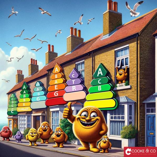
Thanet's Energy Efficiency Unveiled: How A To C EPC Ratings Elevate Margate, Broadstairs, And Ramsgate Homes!
Explore the pivotal role of energy efficiency in Thanet's property market. See how homes in Margate, Broadstairs, and Ramsgate with A to C EPC ratings offer the twin benefits of lower bills and enhanced desirability, contributing to a greener future.
02/04/2024
7130
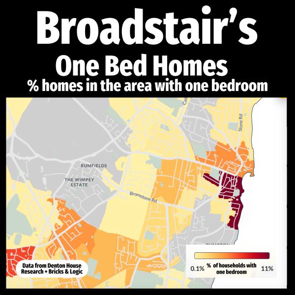
Exploring The Landscape Of One-Bedroom Properties In Margate, Broadstairs, And Ramsgate
Welcome to our latest exploration of the property landscape in Thanet, focusing on the intriguing world of one-bedroom properties in Margate, Broadstairs, and Ramsgate
29/11/2023
6150
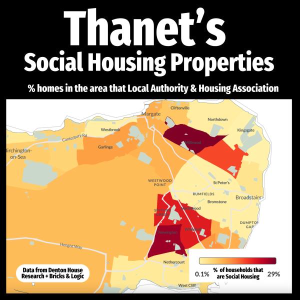
Thanet's Social Housing Landscape: A Comprehensive Heatmap Analysis
This article aims to explore Thanet's social housing distribution, highlighting both local authority and housing association homes. Through the innovative use of heatmaps, we offer an insightful visual breakdown of social housing across the main towns in Thanet, as well as the district as a whole.
13/11/2023
6022
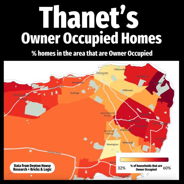
Exploring Homeownership In Thanet: A Deep Dive Into Margate, Ramsgate, And Broadstairs
Homeownership is more than just a status symbol; it’s a significant indicator of community investment, economic stability, and individual financial health. For years, the region of Thanet has been a tapestry of homeownership rates varying from 32% to 60%. However, the area is on the cusp of a transformative phase, with a raft of new developments especially around Westwood towards Ramsgate. While these developments bring promise and potential, they also come with concerns regarding infrastructure needs and the future landscape of property ownership in the area. Our latest heatmap reveals interesting data on Thanet's owner-occupied landscape.
24/10/2023
6568
Search
Categories
#Fairytaleday1
#Fathersday1
#Internet1
#Landlord2
#Letting2
#Price Per Square Foot1
#Tenants1
10Years2
12Months1
17Thfeb1
1952Tonow1
202137
2022149
202363
2023 Tips1
2023]1
202429
2024 New Year1
20253
20281
20501
21Stjune1
2Nddecember1
30Years3
3Tips1
4Beds1
5 Years1
5Reason1
5Thnovember1
Accidental1
Accidents1
Accountable1
Accounting1
Accounts1
Addiction1
Addspace1
Advice261
Advicetips1
Affordable1
Ai2
Airbnb2
Alarm1
All Areas1
Amazing Apartment1
Angelia Raynor MP1
Announcement2
Antibullingweek1
April1
April20241
Aprilfool5
Archetecture1
Aricle1
Arla11
Art1
Artice1
Article4
Articles1
Assistamce0
Assistance1
August2
Autumn5
Average1
Avoid1
Awardwinners1
Awardwinningagents1
Babybank1
Babyboomers1
Backtoschool1
Bargain1
Bathroom1
Batterprice1
Beaches1
Bedroom1
Beinbeforexmas1
Beinsured0
Bekind1
Benice1
Benk1
Beprepared2
Berealistic1
Best Home1
Bestadvice1
Bestpractice1
Bestpractive1
Bettertenants1
Bigchange1
Bitcoin2
Blog5
Bonfirenight1
Bookavaluation1
Breakingnews3
Brexit2
Broadstairs21
Broker1
Btl8
Budget2
Budget20242
Bugs1
Builder1
Builders3
Building5
Building Insurance1
Buildings1
Buildingsurvey1
Bully1
Bungalow2
Bungalows1
Buttolet1
Buy1
Buyer15
Buyers3
Buyersremorse0
Buyi1
Buyin20241
Buyinbg1
Buying88
Buytolet28
Camping1
Canwehelp1
Carbonreduction1
Care1
Carehome1
Cash1
Celebrate1
Celebration3
Census1
Chain2
Chainfree1
Change2
Changeagent1
Charity4
Cheapbuying1
Checklist2
Cheerup1
Chemicalfree1
Children4
Chocholic1
Chooseanestateagent1
Choosetherightagent1
Christmas15
Cleaning4
Clientmopneyprotection1
Closetosesa1
Comment1
Commentary2
Commentry4
Commitments1
Commnetry1
Commuinity1
Community34
Compromise1
Con1
Condensation1
Conflict1
Consideration1
Contents1
Conveyancing1
Cookeandco1
Coronation1
Costof Living1
Costofliving6
Costs2
Council1
Councilowned1
Couple1
Cover1
Covid 194
Crash2
Crime3
Crisis3
Crooks1
Customer Service1
Customers19
Customerservice4
Damiencooke1
Damp1
Daylight1
Debt1
December1
December20231
Declutter1
Decorating2
Decore1
Deposit2
Deposits1
Design1
Det1
Detail1
Detailed1
Developers4
Digital1
Digitaldeclutter1
Dioy1
Disaster1
Disaters1
Distress1
Divorce4
Diy13
Documents1
Doglover1
Dogs3
Donsizing1
Dontdoit1
Dontmissout1
Doomandgloom1
Downsize1
Downvalue1
Dreamhome1
Easter1
Easterarticle1
Eat2
Education1
Elecric1
Election1
Emergency1
Emertgency1
Empty1
Emptyhomes1
Energey Efficiency1
Energy9
Energyperfomancecertificate2
England1
Enigma1
Enjoy2
Entertainment1
Epc6
Estateagencythanet1
Estateagent2
Estateagents1
Ethical1
Eu1
Eurovision1
Eviction2
Ex[Perts0
Exciting5
Expereience1
Experience5
Experts14
Explainations1
Explore1
Fa1
Facts5
Fallthrough2
Families2
Family2
Faq1
Fashion2
Fastest1
February1
Feelgood1
Feeling1
Feelingstuck0
Fengshui1
Figures10
Fillyourproperty1
Film1
Films1
Finacial Services1
Finanace1
Finance1
Finances3
Financialservices12
Firemworks1
First1
First Time Buyer1
Firstbuy1
Firsthome1
Firsttime2
Firsttimebuyer4
Fivestar1
Fivestars1
Fivestarservice2
Flat1
Fleas1
Flowers1
Flythrough1
Follow The Sun1
Foocbank1
Football4
Forsale10
Fourbeds1
Fraud1
Fraudprevention1
Free3
Free Advice0
Freehold1
Freelisting1
Fresh Approach0
Freshstart1
Friendly1
Friends1
Fs2
Ftb6
Fuin1
Fullsurvey1
Fun83
Funfact1
Furnished1
Furnishing1
Future6
Gadgets2
Garageconversion1
Garden5
Gardening2
Gardens2
General26
Generationrent1
Getmoving1
Gettingbestdeal1
Gifts2
Giverment1
Givernment1
Glastonbury1
Globalwarming1
Gogreen1
Golf1
Goodagent3
Goodidea1
Goodluck1
Goodnews2
Goodpractice1
Goodtimes1
Goodtimetosell1
Goodwill1
Google1
Govenment1
Governement1
Government3
Granddesign1
Graph3
Great Stats1
Green3
Greenpolicies1
Grief1
Groundfloor1
Guide1
Hacks2
Happy Christmas1
Happy New Year1
Happychristmas1
Happyeaster1
Happyfathersday0
Happynewyear3
Happypets1
Healthy1
Healthyeating1
Heat1
Heating1
Heatmap1
Heatwave1
Helo0
Help33
Helpftb1
Helpful1
Helpfuladvice1
Helptobuy3
Helptosell1
Heros1
Highervalueproperties1
Hints7
History1
Hmrc1
Hobbies2
Hobby1
Hoints0
Holiday2
Holidays1
Home7
Home Automation1
Homebuyer1
Homegoldmine1
Homehelp1
Homeimprovement6
Homeowner1
Homeowners2
Homeownership1
Homes1
Homeselling1
Homesunderthehammer1
Hometoobig1
Honest1
Honesty1
Hotbuy1
House6
House Price4
Houseblockers1
Househunt1
Housemarket15
Houseplants1
Houseprice2
Houseprices12
Houses1
Housing3
Housingassociation1
Housingshortage1
Howlonginhome1
Icerink1
Ideas6
Iideas1
Iinteriordesign1
Illegal2
Important1
Improved1
Improvements1
Increase3
Indepth2
Ineterst0
Inflation9
Info2
Information2
Informed1
Insight4
Insights1
Inspections1
Inspiration1
Insulation1
Insurance2
Integrity1
Interest3
Interesting2
Interestrate0
Interestrates4
Interference1
International1
Intheknow1
Investment21
Investor2
Investors1
Jan241
January5
Jargon1
Jobs1
Joint1
Jointlet1
Joke1
Journey1
July1
Jumpers1
June20241
Kent3
Kids2
Kindness2
Kitchen1
Knowledge1
Labour2
Landandnewhomes1
Landlord135
Landlord Tips1
Landlordadvic1
Landlords11
Landlords Advice Fun1
Landregistry1
Landregisty1
Lanlordss1
Lattings0
Law2
Leadingagents1
Leapyear1
Leasehold1
Legal3
Legal Advice For Landlords1
Legal Changes1
Legislation25
Legistlation1
Legla1
Letting32
Lettingagent1
Lettingagents1
Lettings9
Lifestyle1
Lift1
Limited1
Links1
Local7
Locate Homes1
Location1
Londonmarathon1
Lonely1
Lookingtobuy1
Lookingtosell1
Losemoney1
Love3
Lovethem1
Lovetohelp1
Luxury2
Maintainance6
Maintaince1
Manaagement1
Management24
Managing1
Managment1
Map1
March 20241
March20241
Margate23
Margateprices1
Margatesales1
Market17
Market Update1
Marketcommentry13
Marketing3
Maths1
Maximise1
May2
May20242
Mental Health1
Mentalhealth5
Mentalwellbing1
Metime1
Mistake1
Modern1
Mogtheringsunday1
Money5
Moneyraised1
Moneysaving1
Mood1
Mortgage6
Mortgages10
Mortgate2
Motherday1
Movenow1
Moving6
Moving In Together1
Movinghome1
Movingin2
Movingintogether1
Movingout1
Movingtips13
Mumanddad2
Mumsmoving1
Music1
Myths1
Naea3
Needsreferbishment1
Negatives1
Negotiation1
New1
New Act1
New Builds4
Newbuild1
Newhome2
Newlaws1
Newnormal2
News3
Newsflash2
Newstart1
Newyearresolutions1
Niovember1
Nocrash1
Nofireworkfun1
Noreductions1
Nosection211
Nosignstopping1
November3
November 20242
Number11
Numberone2
Oap1
Oct242
October9
October 1St1
OEA1
Older2
On Bedroom1
Ontherise1
Organise1
Oroperty1
Ourview1
Outside1
Overprice2
Overpriced1
Overvalue1
Parents1
Partents1
Pastimes1
Payfirst1
Payupfront1
People1
Perfectsteps1
Personalview1
Pests1
Petfriendly1
Pets2
Photos2
Planning1
Plantsnottohave1
Plastic2
Plumbing1
Police1
Politicalcomment1
Politics1
Pop1
Poppies1
Poppy1
Popular1
Portals1
Positive3
Positivestart1
Postiveread1
Ppsqft1
Predictions2
Preditctions1
Preventative1
Prevention1
Price4
Prices5
Pricesurge1
Pricing1
Priopertyprices0
Private1
Pro Tips1
Problem1
Problems2
Process3
Productivity1
Proeprtymarket1
Proffessional2
Proffessionals1
Profit5
Proiperty1
Property16
Propertyanalysis1
Propertyasanivestment1
Propertyexpert1
Propertyexperts2
Propertyfacts1
Propertymanagement1
Propertymarket10
Propertyprices3
Propertystats1
Propertytrends3
Pulse1
Purchase2
Purchaser3
Queries1
Quick Read2
Quickest1
Quickread3
Quicktips1
Quiz1
Ramsgate31
Rates2
Reading1
Ready1
Realisiticprice1
Recipe1
Recommendations2
Redtape1
Reduction2
Reductions1
Referbish2
Reform2
Relationships1
Relax2
Reliaable1
Relocation2
Rememberance1
Remorse1
Remortgage2
Rent1
Rental11
Rental Advice1
Rental Lettings1
Rentalmarket1
Rentalmarketinsights1
Rented5
Renters Reform1
Rentincrease1
Renting15
Rentprotection1
Rents12
Rentstohigh1
Repairs13
Report1
Reservations1
Reslistic1
Respect1
Resposibilities1
Rightagent1
Rise In Prices1
Risingprices1
Robots1
Rollon20231
Rubbish2
Sacrifice1
Sad1
Safetly1
Safety4
Sales7
Santa1
Saturday1
Save4
Savemoney1
Saving1
Saynotobulling1
Scam1
Scams2
Schemes1
School2
Schools1
Schoolsout1
Searches2
Seaside2
Season1
Seaview1
Secondhome1
Secrets6
Security1
Seeling1
Selfbuild1
Sell2
Seller29
Seller Statistics1
Sellers1
Selling142
Sellingwithpets1
Sellnow2
Semi1
Senses1
Service4
Setrent1
Settingthescene1
Sevenquestions1
Sharing1
Shocking1
Shopping1
Short8
Short Read1
Short]0
Shortage2
Shortread3
Shouldibuy1
Shouldisell1
Shouldyoubuy1
Shouldyoulet1
Sizematters1
Smallbusiness1
Smart1
Snowman1
Socailhousing1
Social1
Sofew1
Solar1
Sold4
Solicitors2
Somethingsmaller1
South East Stats1
Southeast1
Spain1
Spare Room1
Specialhome1
Sponsorship1
Sports1
Spring3
Springsoom1
Springtime1
Stampduty3
Starts2
Stateofmarket1
Statisics2
Statistics30
Stats80
Staycation2
Staypositive1
Strategy1
Stress10
Ststs1
Success1
Summer2
Sunday1
Superb1
Support3
Survey2
Switchagents1
Takealoadoff1
Tax7
Tdc1
Tds2
Tea1
Tea Break1
Tea Time1
Teabreak6
Team1
Teatime2
Teatimeread1
Tech3
Teens1
Tenancy5
Tenant29
Tenants14
Tenure1
Terms1
Terrace1
Tesla1
Tgreen1
Thametproperty1
Thanet67
Thanetdistrictcouncil1
Thanetexperts2
Thanetheat1
Thanethomes1
Thanetlettings1
Thanetontheup1
Thanetprices1
Thanetpropertymarket1
Thanetsales1
Thankyou1
Thefuture1
Themarket1
Theplanet1
Things To Avoid1
Thoughtful1
Three Bedroom Homes1
Time2
Timescale1
Timetaken1
Timetomove1
Timetosell1
Tips25
Too Much1
Toptips1
Tory1
Tour1
Tradesman1
Traditions1
Trend1
Trends13
Trust4
Trustus1
Tthanet1
Tv1
Two Bedroom1
Uk3
Uk Property Experts1
UK Property Management1
Ukhousemarket3
Ukhousingtrends1
Uktrends1
Unfurnished1
Unique1
Usecookeandco1
Usp1
Uturn1
Valentine1
Valuation6
Value2
Vandor0
Vendor72
Viewing1
Viewings1
Viewnow1
Voids1
Wabi-Sabi1
Walking1
Websites1
Wecanhelp1
Weekend3
Welovetogetinvolved1
Wfh1
Whatisasurvey1
Whatitmeans3
Whats Next1
Whatshappening1
Whattolookfor1
Why1
Whycookeandco1
Whysolong1
Whyuseus2
Windowbox1
Windows1
Winter1
Winteriscoming1
Women2
Working1
Worldcomaprison1
Worldliteracyday1
Worldsmileday1
Worldview1
Worries1
XMAS10
Yields1
Young1
Youragent1
Tags
#2
#202213
#Buying1
#Landlord3
#Nationalgardeningweek1
#Nationalgardeningweekj0
#Property2
#Tenant2
10 Years1
103Days1
11Th Hour1
19521
19791
1Bed1
1In61
20204
202042
2021148
2022180
2023218
2023Easter1
2024135
20256
20301
20501
241
24 Hours1
30Yearletting1
4Bedroom1
50Hawleysquare1
5Tips1
6Step1
6Yearsold1
6Yr1
7 Days1
7Tips1
9Nterest Rate1
Abroad1
Accident1
Accidents1
Accountant1
Addvalue1
Adult1
Advantages1
Advice181
Aerialtour1
Afterchristmas1
Again1
Ageing1
Agent1
Agentvalue1
Agreement1
Ai1
Airbnb1
Album1
Animals1
Annual1
Annualreport1
Antibullingweek1
Apartment2
April8
April1st1
April20241
April241
Aprilfool3
Arla6
Arrears2
Article3
Articles1
August4
Autumn13
Average3
Averageage1
Averagehouseprice1
Averageprices1
Avergageprice1
Avergagethanet1
Award1
Babyboomer1
Babyboomers1
Back1
Backtoschool1
Badagent1
Badcredit1
Badpractive1
Bank Of England1
Bankofengland3
Bargain1
Bedroom1
Bedrooms1
Bedroomtrends1
Bees1
Best1
Bestpractice2
Billsincluded1
Birds1
Bitcoin1
Blog2
Blue Monday1
Blues1
Blunders1
Books1
Boom1
Boomers1
Breakingnews1
Brexit5
Broadstairs15
Btl6
Budget10
Bugs1
Builders1
Building1
Bully1
Bungalow3
Buster1
Buy4
Buy To Let1
Buyer8
Buyers4
Buying34
Buying Process2
Buyingandselling1
Buytolet15
Buytoletthanet1
Buytoley1
Buytorent2
Calm1
Camping2
Capital Gains4
Carbon Monoxide1
Care1
Carehomes1
Cash1
Cashbuyer1
Cats1
Celebrate0
Celebraties1
Celebration2
Census1
Chain1
Challenges1
Change1
Change Agent0
Change Estate Agent0
Changeagents1
Changeestateagents1
Changes1
Charging1
Charity6
Charm1
Checklist2
Child1
Children2
Chocolate3
Choosing1
Christmas24
Christmas Opening Hours1
Christmassong1
Cleaning7
Clientmoneyprotection0
Closed1
Comingsoon1
Commentry2
Community21
Communoy1
Communuity1
Compare1
Comparison1
Compliance1
Condensation2
Condition1
Confused1
Congratualtions1
Conservative2
Contractors1
Conveyancing3
Cooke & Co9
Cookeandco6
Cookeco2
Cooking1
Cop1
Cost2
Costly1
Costofliving7
Costs1
Councilhouse1
Couple1
Couples1
Covid1
Covid 198
Covid191
Crash3
Crask1
Crime1
Crooks1
Crystal Ball1
Crystalball1
Cuckooing1
Customerservice17
Cut2
Dads1
Damage1
Danger1
Debt1
December4
Declutter1
Decor1
Decorate1
Decorating1
Decore3
Dementia1
Deposits2
Depression1
Design5
Detached2
Detailed1
Developer3
Development3
Differences1
Digital1
Disaster1
Divorce4
Diy8
Dogs5
Dontmissout1
Dontpanic1
Dovorece1
Downsize1
Downsizing2
Dss1
Easter1
Education2
Election2
Electriccars1
Electricity2
Eliots Close1
Emergency2
Emotional1
Empireoflight1
Empty1
Emptyproperty1
Energey1
Energy10
Energycrisis3
Energysaving2
Enviroment1
Epc7
Equity1
Esater1
Estateagency1
Estateagent3
Estateagents1
Ethical1
Eu1
Euro2
Eurovision1
Eviction1
Exciting2
Exclusiveproperty1
Exercise1
Expereinced Agent1
Experience2
Expert1
Experts1
Fairytale1
Fallthrough1
Fallthroughs1
Families1
Family3
Fashion1
Fatherday1
Fathersday1
Fear1
Fengshui1
Festivals1
Festive1
Ffun1
Figures1
Films1
Finace1
Finacial Service1
Finacialadvice2
Finance4
Findnewhome1
Fireworks2
First Time Buyer3
First Time Buyers1
Firsthome1
Firsttime1
Firsttimebuy1
Firsttimebuyer12
Firsttimerenter1
Firttimebuyer1
Fivesenses1
Fivestars1
Fivestarservice1
Flat1
Foodbank1
Foodwasteweek1
Football2
Forecast1
Forsale8
Fraud4
Freehold1
Freshstart1
Friends2
Fs1
Ftb9
Fullreport1
Fun46
Fun Advice2
Future4
Gadgets2
Gains1
Games1
Garage1
Garden11
Gardens2
Gas1
Gen1
General12
General Election1
Generation2
Genz1
Getmoving2
Gifts2
Glastonbury1
Globalmortgage1
Gloomandoom1
Good Agent1
Good Ideal1
Good News1
Goodagent2
Goodestateagent2
Goodnews1
Goodpractice1
Goodtimes1
Google1
Govenment2
Government2
Granny1
Graph1
Greatagents1
Green4
Greetings1
Groundfloor1
Growyourown1
Guarentor1
Guide1
Hacks1
Hainelodge1
Halloween4
Handytips2
Happy0
Happy New Year1
Happyeaster2
Happyfathersday1
Happynewyear3
Health1
Heartfoundation1
Heatmap10
Heatmaps4
Help11
Helpbuying1
Helpselling1
Helptobuy1
Helptosell1
Hiddenspace1
Highervalue1
Hints2
Historicprices3
History3
Hmo1
Hmrc1
Hobby1
Hoiliday1
Holiday1
Holidayrent1
Holidays1
Holidayseason1
Home5
Homebuyer1
Homehacks1
Homeimprovements1
Homeinsurance1
Homeowner12
Homeownership3
Homes2
Homestaging1
Homesunderythehammer1
Honest1
Hot1
House Market3
House Prices29
Househunt1
Houseing1
Housemarket9
Houseplants1
Houseprice16
Houseprices9
Houses1
Houseshare1
Housing1
Housing Crisis1
Housing Market1
Housingcrisis2
Housingladder1
Housingmarket5
How Long1
How Long To Sell1
Hunt1
Ice1
Icerink1
Ideas6
Iinflation1
Imortgage1
Improvements2
Includebills1
Increasevalue2
Inetrnationalwomensday1
Inflation11
Information1
Inheritance5
Inpection1
Insight1
Insights1
Inspections1
Inspiration1
Instagram1
Insulation1
Insurance2
Interest11
Interesting2
Interestrate1
Interestrates2
Interiordesign1
Internet1
Inventory1
Investing1
Investment16
Investment Buy To Let1
Investments1
Investor1
Investors1
Itcominghome1
January1
Jargon1
Jeremyhunt1
Jeremyhuny1
Jobs2
Jointtenants1
Journeys1
Joy1
Joys2
July4
Jumpers1
June3
June241
Kids3
Kindness2
Kingcharles1
Kitchen2
Km1
Labour1
Land1
Landl;Ord1
Landlord148
Landlordchecklist1
Landlords16
Lanlord1
Lanlords0
Lastthree1
Law2
Laywer1
Ldecember1
Leadership1
Leasehold1
Legal1
Legislation20
Legit1
Letting19
Lettings10
Lettingwithfriends1
Lifetime Deposit1
Light2
Lights1
Limited1
Lioness1
Lletting1
Local5
Localauthority1
Loft1
London1
Long Article Stats1
Lonley1
Lookahead1
Lookfor1
Love3
Loves1
Luxury1
Lvendor1
Maintain1
Maintainance3
Makingtaxdigital1
Management8
Marathon1
March2
Margate22
Market15
Market Insight1
Marketcommentry9
Marketing3
Markets1
Mature1
May8
Mentalhealth12
Message1
Mistake1
Mistakes2
Modern1
Moneysaving1
Monthly1
Monthonmoth1
Morespace1
Morgage1
Mortgage15
Mortgagerates1
Mortgages1
Mortgate1
Mortgaterate1
Morthgage Freedom1
Mot1
Mother1
Mothers1
Mothersday2
Mould1
Movein1
Moving6
Mulitigenerational2
Mums1
Music2
Myths3
Naea2
National Average1
Nationalteaday1
Naturallight1
Negative1
New Build1
Newbuild4
Newdevelopment2
Newhome2
Newhomes2
Newnormal4
News1
Nightmare1
No Section 211
No Services1
Notice1
Nov241
November7
November 241
November242
November5th1
Novemver1
Numbersold1
Oap1
Obligations1
October10
Offer1
Oldertenants1
Oldtownmews1
Olympics1
Ombudsman1
Onebedroom1
Online1
Opening Times1
Optimistic1
Over501
Overcrowding1
Overpayment1
Overpricing1
Overvalue1
Overvaluing3
Pandemic1
Paperwork1
Parenting1
Parents2
Partner1
Personal1
Pests1
Pets9
Photographs1
Photography1
Pitfalls2
Planning3
Plants1
Plastic2
Poem1
Politics2
Pollen1
Poltics1
Poppy Day1
Popular1
Portals1
Portfolio1
Posh1
Ppsqft1
Predictions1
Price1
Price Smart1
Pricedrop1
Pricerise1
Prices3
Pricing1
Private2
Privatelandlord1
Privatesale1
Probate2
Problems3
Process1
Professional1
Profit1
Progression2
Properttymarket1
Property21
Property Coownership1
Property Market2
Propertyexperts1
Propertyinsights1
Propertyinvestmentinsights1
Propertyinvestmenttips1
Propertymarket20
Propertyprice1
Propertyprices4
Propertystats3
Propertysurge1
Propertyupdate2
Purchase1
Purchaser2
Quarter 21
Quarter One1
Quatar1
Questions2
Quickread1
Quiz1
Ramance1
Ramsgate24
Rate1
Rates3
Reading1
Readytomove1
Readytosell1
Recession1
Recommended1
Recycle1
Redflags1
Reduce1
Reduction1
Reductions3
Referb1
Reference1
References1
Refubishment1
Regret0
Relax1
Relocation1
Rememberance2
Remorse1
Rent2
Rental8
Rented6
Renter Right1
Renters Act1
Renters Reform1
Rentersreform1
Renting5
Rentorsell1
Rents18
Reolutions1
Repairs10
Reports1
Repurposing1
Research1
Reservations1
Resolutions1
Retail1
Reterreform1
Retire1
Retirement1
Return1
Review2
Reviews1
Rics1
Rightmove1
Rights1
Righttime1
Rise1
Rises2
Robbery1
Robottakeover1
Royal British Legion1
Sad1
Sadness1
Safety2
Sales10
Salesupdate1
Save1
Savetheplanet2
Savethousands1
Scams2
School1
Schools1
Scrabble1
Seaside1
Seasons1
Secondtimearound1
Secret Tips1
Secrets2
Section211
Section81
Security3
Selfbuild1
Selfmanage1
Sell1
Sellafterbuy1
Sellbeforebuy1
Seller15
Sellhomefaster1
Selling106
Selling Process4
Selling Tips1
Sellingblunders1
Sellingmyhomne1
Sellingtips1
Selliptips1
Selloff1
Semidetached1
September7
Shoplocal2
Shopping1
Short6
Shortage1
Shortread3
Shouldisell1
Showdown1
Sixbuyertypes1
Sixtips1
Sizematters1
Smallbusiness1
Smart1
Socailhousing1
Socails1
Social1
Social Media1
Sold4
Solicitor1
Solicitors2
Southeast2
Spacious1
Spain1
Special1
Spingclean1
Spratlingland1
Spring16
Sq Ft1
Sqft3
Squirrels1
Staging1
Stamp Duty2
Stampduty1
Starmer1
Starts1
Statisics1
Statistic1
Statrs1
Stats56
Staycation2
Stayin1
Storage1
Stress7
Stressreduction1
Stressrelief1
Style1
Styles1
Summer3
Summerscoming1
Sun1
Sunday1
Supply1
Support2
Suprise1
Surge1
Surveys1
Switch1
Tax6
Taxcuts1
Tea Time Read1
Teabreak12
Teabreakread1
Team1
Teatime7
Tech4
Teen1
Teenmoving1
Tenancies1
Tenancy2
Tenant26
Tenant Abandonment1
Tenants10
Tenats1
Tenure1
Terms1
Terraced3
Thanet82
Thanet Homes1
Thanet Property Market1
Thanetlandlords1
Thanetoctober1
Thanetproperty1
Thankyou1
Thatcher1
Themarket1
Threebeds1
Tiktok1
Time1
Timetosell2
Tip1
Tips16
Too Many1
Top31
Torent1
Tory2
Tradesman1
Trands1
Trends8
Tricks1
Tthoughts1
Tufty1
Tunes1
Tv2
Uk2
Uk Property1
Ukhousemarket1
Ukhousing2
Ukproperty1
Ukrealestatetrends1
Unscrupulous1
Unusual1
Update1
Usecookeandco0
Valentine1
Valentines1
Valuation6
Value1
Valuing1
Vegetables1
Vendor48
Vermin1
Vicki1
Viewings2
Voids1
Wabi-Sabi1
Waitinglist1
Waling1
Warning0
Waste1
Wecanhelp1
Wewillremeberthem1
Whatsbest1
Whatsthemarketdoing1
Whychooseus2
Wildlife1
Willitcrash2
Windowbox1
Windows1
Winter5
Women1
Work1
Workfromhome1
World2
Worldcup2
Worldmusicday1
Worldphotographyday1
Worldscrabbleday1
Worldsmileday1
Worry1
Xmas14
Xmaschecklist1
Yields1
Young1
Youtube1
